Note: This article is formatted for direct web publishing, and the SEO tags appear in JSON format at the end of the body.
Hurricanes do not show up out of nowhere like surprise guests with bad timing and worse manners. They build slowly, gathering heat, moisture, structure, and momentum over warm tropical water until the atmosphere decides it is time to make headlines. If you want to understand how hurricanes form, Hurricane Florence in 2018 is a nearly perfect case study. It had the classic ingredients meteorologists watch for, it intensified dramatically over the Atlantic, and even after weakening before landfall, it still became a historic disaster because of flooding.
That is the first big lesson: hurricanes are not just about wind. Wind gets the flashy photos. Water does the long-term damage. Florence proved that in unforgettable fashion.
What a Hurricane Actually Is
A hurricane is a tropical cyclone that forms over warm ocean water and reaches sustained winds of at least 74 miles per hour. Before a storm earns that title, it usually passes through a sequence of stages: tropical disturbance, tropical depression, tropical storm, and then hurricane. In simple terms, a hurricane is a rotating low-pressure system powered by warm water and organized thunderstorms.
Think of it like a heat engine floating over the ocean. Warm seawater evaporates, moisture rises, clouds build, and the condensation of that moisture releases heat into the atmosphere. That released heat helps the storm grow stronger, which allows it to pull in even more warm, moist air. It is a feedback loop, and when the atmosphere cooperates, the result can be enormous.
How Do Hurricanes Form?
To build a hurricane, nature needs a very specific recipe. Leave out one ingredient and the whole thing can fizzle. Get them all together, and the atmosphere starts cooking with alarming confidence.
1. Warm Ocean Water
The first ingredient is warm water, and not just a lukewarm splash. Hurricanes generally need ocean temperatures of at least about 80 degrees Fahrenheit, or 26.5 degrees Celsius, with that warmth extending down into the upper layer of the sea. Warm water is the fuel supply. It feeds evaporation, and that moisture becomes the raw material for thunderstorm development.
This is why hurricanes form over tropical and subtropical oceans rather than over cool water or land. Once a storm moves over colder water or inland, its energy source weakens. It is like unplugging a machine that was running at full blast.
2. A Preexisting Weather Disturbance
Most Atlantic hurricanes do not begin as fully organized storms. They often start as tropical waves, which are areas of lower pressure moving westward from Africa through the tropics. These waves can trigger clusters of showers and thunderstorms. Most never become anything special. A few, however, find themselves in just the right environment and begin organizing.
That early organization matters because a hurricane needs a center. Air must start converging toward a low-pressure area, rising, cooling, and forming taller and deeper thunderstorm towers. No disturbance, no party.
3. Plenty of Moisture
Dry air is the rude neighbor of tropical development. Hurricanes prefer a humid atmosphere, especially in the lower and middle levels. Moist air keeps thunderstorms alive and helps the storm maintain deep convection, which is the upward movement of warm, moist air that drives tropical systems.
When dry air slips into the circulation, it can weaken thunderstorms, disrupt the warm core of the storm, and slow development. This is one reason some promising tropical systems end up doing little more than becoming names on a weather map.
4. Low Vertical Wind Shear
Wind shear is the change in wind speed or direction with height. Hurricanes hate strong wind shear. If winds at different levels of the atmosphere blow too differently, they tilt and disrupt the storm’s vertical structure. Picture trying to stack a tower of blocks while someone keeps shoving the top sideways. Not ideal.
For a hurricane to grow, the storm needs to stay vertically aligned so rising air, thunderstorm bursts, and the circulation center remain connected. Low wind shear allows the storm to keep its shape and strengthen efficiently.
5. Enough Distance from the Equator
Hurricanes almost never form right at the equator because they need the Coriolis effect, the apparent turning force caused by Earth’s rotation. This effect helps the storm spin and organize. Close to the equator, that spin is too weak. Generally, storms need to form at least a few degrees north or south of it.
So yes, a hurricane needs heat, moisture, and spin. Meteorology is not magic, but sometimes it behaves like it enjoys dramatic entrances.
6. Thunderstorms That Keep Recycling Energy
As warm, moist air rises into thunderstorms, it cools and condenses into cloud droplets. That process releases latent heat, which warms the surrounding air and lowers pressure further. Lower pressure draws in more air at the surface, which rises again, and the cycle continues. This repeated energy recycling is how a loosely organized tropical system can grow into a large, dangerous hurricane.
The Structure of a Hurricane
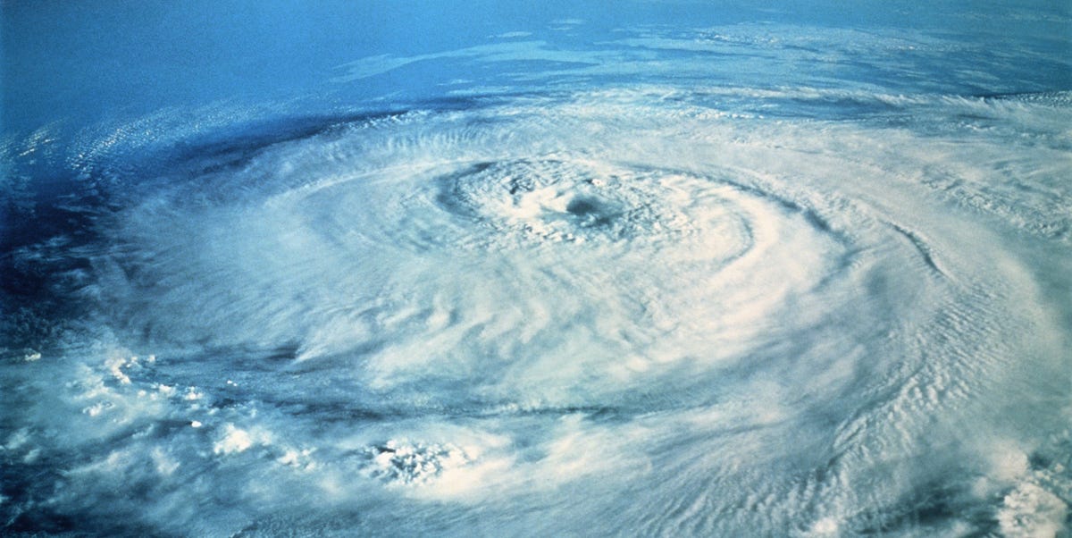
Once a hurricane matures, it develops several recognizable features. At the center is the eye, a relatively calm area where skies can partially clear. Around it is the eyewall, the ring of intense thunderstorms that contains the strongest winds and heaviest rain. Outside that are spiral rainbands, which can stretch far from the center and bring bursts of heavy rain, wind, and even tornadoes.
This structure is important because many people mistakenly focus only on the eye. In reality, hazards can begin long before the center arrives. Rainbands can flood neighborhoods, storm surge can push inland, and tropical-storm-force winds can knock out power far from the eye itself.
Hurricane Florence 2018: A Real-World Example
Hurricane Florence in 2018 is a powerful example of how a hurricane forms, intensifies, changes, and still remains dangerous even when wind speeds decrease. Florence began as a tropical wave off Africa, the same birthplace that launches many Atlantic hurricanes. It moved over warm Atlantic water, found a favorable environment with relatively low shear, and gradually organized into a stronger tropical cyclone.
By early September 2018, Florence had become a major hurricane. At one point over the Atlantic, it reached Category 4 strength with maximum sustained winds near 140 miles per hour. That is the kind of wind speed that makes weather maps look like they are trying to shout.
But then Florence delivered the most important hurricane lesson of all: the category number never tells the whole story.
Why Florence Strengthened
Florence had the textbook setup for intensification. It was over warm water, it had access to abundant tropical moisture, and the storm’s internal circulation became better organized. Strong thunderstorms wrapped around the center, the pressure dropped, and the wind field responded. In other words, the atmosphere handed Florence a full tank of gas and a clear runway.
For several days, Florence looked like the kind of storm coastal residents fear most: large, organized, and potentially devastating at landfall.
Why Florence Weakened but Stayed Dangerous
Before landfall, Florence weakened from a Category 4 hurricane to a Category 1 storm. Some people saw the lower category and assumed the threat had dropped sharply. That was a costly misunderstanding.
Even though the strongest winds decreased, Florence remained a huge storm carrying extraordinary amounts of moisture. It made landfall near Wrightsville Beach, North Carolina, on September 14, 2018, as a Category 1 hurricane. Then it slowed down dramatically over land, crawling at only about 2 to 3 miles per hour for a time. That sluggish movement turned the Carolinas into the storm’s rain bucket.
A slow hurricane is often worse than a fast one when it comes to inland flooding. Instead of moving through and leaving, it parks itself over the same region and keeps unloading water hour after hour, day after day. Florence basically stepped on the brakes and left the shower running.
Rain, Flooding, and the Real Disaster
Florence became historic because of rainfall and freshwater flooding. Parts of North Carolina recorded astonishing totals. Elizabethtown logged 35.93 inches of rain, and many other locations set new records. NASA reported that multiple towns received more than 20 inches, with some places surpassing 33 inches. Rivers swelled, roads disappeared under water, and communities became isolated.
That is why understanding hurricane formation also means understanding hurricane impact. The same warm-ocean energy that helps a storm build also loads it with moisture. When the storm slows down over land, all that moisture has to go somewhere. Usually, the answer is into neighborhoods, highways, creeks, rivers, and basements that absolutely did not ask for a visit.
Florence also brought storm surge, power outages, coastal damage, and long-lasting disruption. But its flooding footprint is what made it stand out. It reminded the public that inland communities can face enormous risk even if they are not right on the beach.
What Florence Teaches About How Hurricanes Form
Florence was not weird in the way it formed. It followed the standard tropical cyclone playbook. What made it memorable was how clearly it showed the relationship between hurricane science and real-world impact.
First, it showed why warm water matters. Without ocean heat, Florence never would have become a major hurricane. Second, it showed why moisture matters. The atmosphere carried a tremendous amount of water that later fell over the Carolinas. Third, it showed why wind shear matters. In its more favorable phases, Florence was able to organize and intensify. Finally, it showed that weakening wind does not equal harmless weather. A hurricane can lose category strength and still deliver catastrophic flooding.
If there is one myth Florence should have buried for good, it is the idea that hurricane danger can be judged by category alone. The Saffir-Simpson scale measures wind, not rainfall totals, storm size, forward speed, or freshwater flood potential. Florence was a master class in why that distinction matters.
What People Should Expect During a Hurricane
When a hurricane approaches, the danger usually arrives in layers. First come forecasts, advisories, and a growing sense that the weather is no longer just conversation material. Then come rough surf, bands of rain, rising winds, and possible evacuation orders. After that, the main hazards can include storm surge near the coast, destructive wind, tornadoes in outer bands, flash flooding, river flooding, long power outages, and dangerous conditions that continue even after the eye has passed.
Floodwater is one of the most serious post-storm hazards. It can hide debris, chemicals, downed power lines, and contamination. A hurricane may be over on the radar while the most dangerous part of the event is still unfolding on the ground.
Experience Section: What Living Through a Storm Like Florence Feels Like
To understand Hurricane Florence on a human level, it helps to imagine the experience in phases rather than in one dramatic movie scene. Real hurricanes are rarely just one wild moment. They are long, exhausting events.
Before the storm, the mood often shifts gradually. At first, people check forecasts with one eyebrow raised, as if the storm might still change its mind. Then the forecast cone tightens, local stores get crowded, gas lines grow longer, and plywood starts appearing over windows. The ordinary routine of life begins to wobble. School schedules change. Grocery carts fill with bottled water, batteries, peanut butter, and snacks that can survive both humidity and bad decisions.
Then comes the strange calm of waiting. The sky may not look dramatic yet, but everyone knows something is on the way. Phones stay charged. Flashlights get tested. Families text each other more than usual. You start listening to weather updates the way fans listen to the last minute of a close game, except nobody is having fun and the stakes are much higher.
During a storm like Florence, one of the most unsettling things is not always the wind. It is the duration. Rain keeps falling. The wind keeps pushing. The sound outside never really stops. The hours blur together, especially if the power goes out. Day and night begin to feel interchangeable. You realize quickly that hurricanes are not only violent; they are relentless.
For many people in the Carolinas during Florence, the worst part was watching water keep rising long after they thought the peak danger should have passed. Streets that seemed manageable in the morning looked like canals by evening. Creeks spilled into yards. Rivers climbed out of their banks. Roads closed one by one. Some communities ended up feeling cut off from the rest of the world.
Afterward, the experience changes again. The storm leaves, but the work begins. Cleanup is slow. Normal life does not snap back overnight. There can be mud, debris, spoiled food, damaged roofs, soaked drywall, closed schools, and months of repair. Neighbors help neighbors. Volunteers show up. People trade generators, extension cords, hot meals, and information. The recovery becomes a community story as much as a weather story.
That is why Florence still matters. It was not just a hurricane on a map in 2018. It was a lesson in patience, risk, preparation, and respect for water. It showed how a storm can weaken on paper and still become a life-changing event in reality. And for anyone who wants to know how hurricanes form, Florence offers an unforgettable answer: they begin with heat and moisture over the ocean, but their true story is written in what happens when that energy reaches people, towns, rivers, and coastlines.
Conclusion
So, how do hurricanes form? They form when warm ocean water, humid air, low pressure, low wind shear, atmospheric instability, and Earth’s rotation all line up in the right place at the right time. Thunderstorms organize, pressure falls, winds increase, and a tropical system can grow into a hurricane.
Hurricane Florence in 2018 followed that path from tropical wave to major Atlantic hurricane. But its legacy came from what happened after formation: a slow-moving landfall, staggering rainfall, record flooding, and a hard reminder that water is often the deadliest part of the storm. If you want one sentence to remember, make it this: hurricanes are born over warm water, but their danger depends on far more than wind speed alone.