Garmin has spent years building watches that can track nearly everything an outdoor athlete does. They count steps, estimate recovery, monitor elevation, measure heart rate, display maps, and politely remind you that yesterday’s workout was “unproductive.” Naturally, the next step was helping users decide where to hike in the first place.
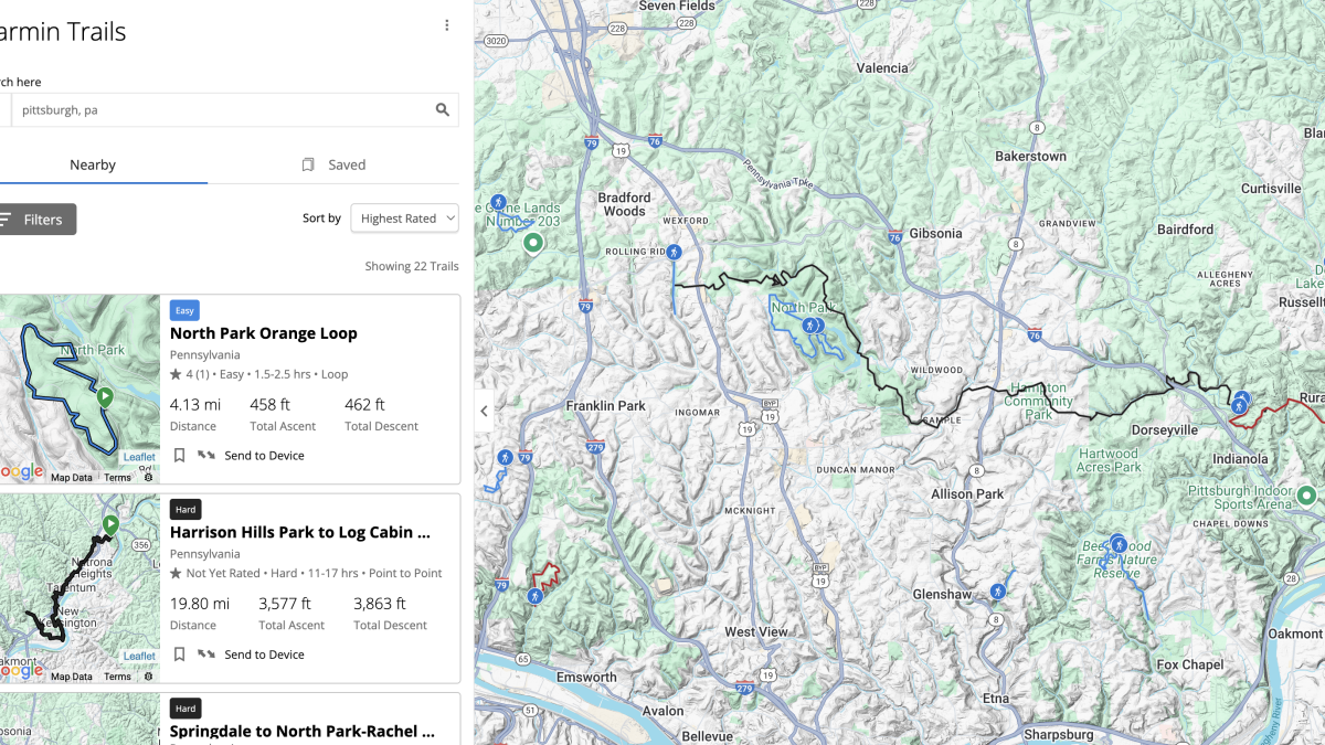
That is the idea behind Garmin Trails, a trail-discovery feature available through the Garmin Connect and Garmin Explore apps. Users can browse nearby hiking, backpacking, and trail-running routes, filter them by practical criteria, read community feedback, andunder certain subscription planssend a selected route directly to a compatible Garmin device.
On paper, it sounds like the missing link in Garmin’s outdoor ecosystem. Find a route, send it to your watch, lace up your shoes, and disappear into the woods without juggling three apps and a suspiciously crumpled printout.
There is just one awkward problem: a trail finder is only as useful as the trails it can find. During its early rollout, Garmin Trails often displayed the famous routes while overlooking local favorites, alternate loops, neighborhood trail systems, and the less glamorous paths that experienced hikers actually use.
What Is Garmin Trails?
Garmin Trails is a curated trail database designed to help users discover routes for hiking, backpacking, and trail running. It can be accessed from the Training and Planning section of Garmin Connect or through the map tools in Garmin Explore.
Garmin lets users filter trails by:
- Distance
- Total ascent
- Difficulty level
- Trail rating
- Loop, out-and-back, or point-to-point format
- Features such as waterfalls, scenic views, dog access, or family suitability
Trail pages may include a route map, elevation information, descriptions, ratings, reviews, recommended seasons, and other planning details. Garmin currently promotes the service as a collection of thousands of trails available in selected regions. An active Garmin Connect+ or Outdoor Maps+ plan is required to send trails directly to compatible devices for offline use or save editable copies as Garmin Courses.
This workflow is attractive because it keeps route planning inside the Garmin ecosystem. Instead of finding a hike elsewhere, downloading a GPX file, importing it into Garmin Connect, syncing the watch, and hoping the file did not transform into modern art, users can theoretically complete the process in a few taps.
Why Garmin’s Trail Finder Is a Genuinely Good Idea
It connects discovery with navigation
Garmin has long offered excellent on-device navigation, especially on higher-end Fenix, Epix, Enduro, Forerunner, Instinct, and Edge models. The company’s weakness was not necessarily following a route; it was helping users find an appropriate route before the activity began.
Garmin Trails attempts to close that gap. When the desired hike appears in the database, the experience is pleasantly simple. You can inspect the trail, review the distance and climbing, send it to your watch, and navigate without keeping your phone screen awake for five hours.
That matters on long hikes. A watch is easier to glance at, more weather-resistant, and less likely to be dropped into a creek while you attempt to photograph a salamander.
The filters are practical
The filters are not merely decorative. Distance, elevation gain, route format, and difficulty are among the most useful variables when choosing a hike.
A six-mile loop with 500 feet of climbing is a very different Saturday from a six-mile climb gaining 3,000 feet. Both may be described as “moderate” by someone who considers eating a granola bar a full recovery strategy.
Garmin’s ability to combine these criteria makes the tool useful for selecting routes based on available time, fitness, weather, and the enthusiasm level of one’s hiking companions.
Offline watch navigation is convenient
Sending a trail to a compatible Garmin watch creates a strong all-in-one experience. Depending on the device, users may receive course lines, turn prompts, distance remaining, elevation profiles, off-course notifications, and other navigation information.
That does not eliminate the need for basic navigation skills or backup maps. However, it can reduce the number of times a hiker must stop, unlock a phone, wait for a map to load, and discover that the battery has fallen from 42% to “good luck.”
The Big Problem: Garmin Trails Is Still Missing Too Many Trails
The feature’s weakness became obvious when early users searched areas they knew well. Garmin often included an iconic route or two but omitted nearby alternatives, connector trails, trailhead variations, and established local loops.
One launch-era comparison examined the Three Sisters Falls area in California. Garmin reportedly showed one route to the waterfall and 19 trails in the wider area. AllTrails displayed four waterfall-route options and 143 trails across the same general region.
Another test around Mount Diablo found no Garmin Trails routes beginning at a popular parking area used by hikers heading toward the summit. Across a large portion of Northern California, Garmin showed roughly 500 hikes, while a single county within that region reportedly contained more than 500 listings on AllTrails.
Those comparisons do not mean every AllTrails listing is unique, official, safe, or worth doing. Trail databases frequently contain duplicate routes, minor variations, poorly named tracks, seasonal roads, and combinations invented by users who apparently navigate by following squirrels.
Still, the difference illustrates Garmin’s central challenge. A curated collection can be cleaner than an enormous community database, but it must be sufficiently complete to reflect how people actually explore an area.
Why a Trail Can Exist on the Map but Not in the Finder
It may seem strange that a path can appear on a Garmin topographic map yet remain absent from Garmin Trails. The reason is that map data and a searchable trail catalog are not the same product.
A path is not automatically a complete route
A digital map may contain individual trail segments without packaging them into a named hike. To create a discoverable trail listing, Garmin needs to determine which segments belong together, where the route begins, where it ends, how difficult it is, and whether it represents a loop, out-and-back, or point-to-point trip.
Consider a state park with twelve intersecting paths. Those paths might support dozens of sensible hikes. A map can display all twelve, but a trail finder must decide which combinations deserve individual listings.
Local trails often have multiple valid versions
Experienced hikers rarely use trails in only one approved configuration. A summit may be reached from three trailheads. A waterfall hike may have a short family route, a longer loop, and a steep approach from another road.
Garmin’s early approach tended to offer one representative route where established competitors might show several useful variations. That keeps the results tidy, but it can also make a familiar trail system look strangely empty.
Access information can be complicated
Outdoor maps must distinguish between official trails, informal paths, private roads, seasonal closures, abandoned routes, and trails whose access status changes faster than a group chat planning a weekend hike.
An early Garmin Trails field test revealed a route directing the user toward an immovable fence surrounded by barbed wire. The correct turnaround point was reached only after going off the suggested course. Garmin provides a tool for reporting trail problems, but this example shows why route validation matters.
More routes are not automatically better if the extra routes cross private property, enter closed areas, or follow unofficial social trails. The National Park Service recommends planning ahead, checking current conditions, carrying appropriate navigation tools, and using official information because closures and trail conditions can change.
Community databases have a major head start
AllTrails, Komoot, Trailforks, and similar platforms have spent years collecting route uploads, reviews, photos, corrections, and local knowledge. Their users create a feedback cycle: more routes attract more users, and more users generate more information.
Garmin has millions of active customers and an enormous volume of recorded activity data. Its Trendline Popularity Routing already uses aggregated Garmin Connect activity information to identify frequently traveled roads and trails. However, converting popularity data into accurate, named, reviewed trail listings is a separate task.
Garmin Trails can eventually build a strong community layer, but ratings and reviews are not very persuasive when a route has one rating, no comments, and the emotional energy of an empty restaurant at 7 p.m.
The Subscription Question
Browsing Garmin Trails is available without paying for Garmin Connect+. The premium restriction becomes important when a user wants to send a selected trail directly to a compatible device or save it for offline navigation.
This distinction has frustrated some Garmin owners. Many have already paid hundreds of dollars for watches marketed around outdoor navigation. Asking for another subscription to simplify route transfer can feel like buying a very expensive toaster and discovering that the toast button requires a membership.
Garmin Connect+ launched in 2025 at $6.99 per month or $69.99 annually, alongside features such as Active Intelligence, performance dashboards, expanded LiveTrack tools, enhanced coaching content, and premium profile options. Garmin said existing health data and previously available features would remain free.
Garmin Trails therefore serves two roles. It is an outdoor-planning feature, but it is also an incentive to subscribe. That is reasonable from a business perspective, although the value proposition becomes harder to defend when the database does not include the routes a subscriber wants.
Garmin Trails vs. AllTrails, Komoot, Courses, and Trailforks
Garmin Trails
Garmin Trails offers the cleanest experience for users who want to remain entirely within Garmin Connect or Garmin Explore. Its biggest advantages are direct device integration, familiar Garmin controls, and convenient filters.
Its biggest weakness is catalog depth. In many areas, the database feels more like a carefully selected starter pack than a complete guide.
AllTrails
AllTrails remains strong for general trail discovery because of its large catalog, community reviews, photographs, recent trip reports, and extensive filters. It commonly provides several route variations from the same trailhead.
Its size can also create clutter. Duplicate listings and questionable user-generated routes require judgment. Still, when the goal is finding as many established local hikes as possible, its coverage is difficult to ignore.
Komoot
Komoot is particularly useful for customized route planning and multi-sport adventures. Garmin and Komoot accounts can be connected so saved routes transfer into Garmin as Courses. Navigation instructions are then calculated through Garmin’s interface, and long routes may be simplified depending on the device.
Komoot is a better choice for users who want to design a precise route rather than select a predefined hike.
Garmin Courses
Garmin Courses already allows users to create, import, edit, and send routes to their devices. It lacks some of the polished discovery features of Garmin Trails, but it remains useful and does not make every route transfer dependent on finding that route in Garmin’s curated database.
If your favorite hike is missing, importing a trusted GPX file or drawing the route manually may still be the most direct solution.
Trailforks
Trailforks is especially valuable for mountain biking, although it also includes hiking and multi-use routes. Compatible Garmin accounts and devices can receive Trailforks trails and routes through Garmin’s integration tools.
This is another reminder that Garmin Trails does not need to replace every outdoor service. It simply needs to become complete enough that opening another app is optional rather than mandatory.
How to Use Garmin Trails Without Getting Misled
Garmin Trails can be helpful today, provided it is treated as one planning resource rather than an unquestionable authority.
- Compare the route with an official map. Check park, forest, or land-management websites for current closures and approved trails.
- Read recent reviews. Old ratings may not reflect washed-out bridges, construction, snow, wildfire damage, or temporary access restrictions.
- Inspect the route shape. Zoom in around gates, road crossings, junctions, and turnaround points.
- Download the route before leaving. Do not assume cellular service will appear precisely when you become confused.
- Carry a backup. A paper map, compass, second device, or offline park map can prevent a minor navigation problem from becoming an overnight biography.
- Report errors. Missing details, inaccurate paths, and access problems should be submitted through Garmin’s reporting tools.
What Garmin Needs to Improve
Add more route variations
Garmin should avoid limiting major trailheads to one “official” hike. Short, long, accessible, scenic, and challenging variations can all be valuable when clearly labeled.
Use Garmin activity data more aggressively
Garmin already knows which routes its users repeatedly travel. Privacy-conscious analysis of aggregated activity patterns could help identify missing popular loops and trailhead combinations.
Improve community contributions
Users should be able to suggest new trail listings, submit route corrections, attach current condition reports, and propose alternate versions. Contributions would require moderation, but Garmin’s outdoor community is too knowledgeable to remain limited to star ratings and comments.
Show the source and verification status
Each route should indicate whether it was verified by Garmin, supplied by a land manager, derived from community data, or created from aggregated activity patterns. A visible “last reviewed” date would help users judge reliability.
Make safety information more prominent
Seasonal closures, private-property boundaries, permit requirements, water availability, dangerous crossings, and heat warnings should be easier to see before a trail is transferred to a watch.
Who Will Like Garmin Trails Right Now?
Garmin Trails is most useful for casual hikers and trail runners searching for well-known routes in supported regions. It works especially well when the desired trail is already listed and the user values fast synchronization with a Garmin device.
It is less convincing for hikers who frequently explore local trail networks, create custom loops, travel beyond supported areas, or rely on obscure access points. Those users will probably continue combining Garmin navigation with AllTrails, Komoot, Trailforks, official park maps, local hiking groups, and manually imported GPX files.
Trail Experience: When the App Knows the Mountain but Not My Hike
The first time I opened a new trail-discovery tool, I did what most experienced hikers probably do: I ignored its featured destinations and searched for a route I already knew.
This is the fastest way to evaluate a map. A familiar trail exposes missing junctions, inaccurate mileage, strange access points, and route choices that look reasonable on a screen but make no sense on the ground.
Garmin Trails recognized the general area immediately. The major park appeared, along with its famous summit route and a scenic loop that attracts enough weekend traffic to create its own weather system. The results looked polished. Distances were clear, elevation totals were easy to compare, and the filters quickly removed routes that were too long for an afternoon hike.
Then I searched for my favorite trail.
Nothing.
I tried the official name, the local nickname, the trailhead name, and the nearby landmark. I moved the map, cleared the filters, zoomed in, zoomed out, and performed the familiar ritual of blaming myself before blaming the software.
The physical path was visible on the underlying map. Garmin knew a trail existed there. What it did not provide was the route I regularly followed: a loop combining two wooded paths, a ridge connector, and a short section of service road.
The suggested alternative began from a larger parking lot and followed the most obvious route. It was not bad. In fact, I would recommend it to a first-time visitor. But it missed the reason I liked hiking therethe quieter approach, the gradual climb, and the overlook reached before the main trail became crowded.
That experience clarified the difference between discovering a destination and understanding a trail system. Garmin Trails knew where visitors went. It did not yet understand all the ways local hikers moved through the landscape.
I eventually created the route manually as a Garmin Course. The process worked, but it weakened the promise of the new finder. I had opened Garmin Trails to avoid drawing another course, and five minutes later I was placing points on a map like a cartographer who had missed lunch.
On the actual hike, the Garmin watch performed well. The course line was easy to follow, junction alerts appeared at useful times, and the elevation profile helped estimate how much climbing remained. This is where Garmin continues to shine: once a good route reaches the watch, the navigation experience can be excellent.
The frustrating part happened before the hike. Garmin had built an impressive bridge between trail discovery and wrist navigation, but my route was standing on the wrong side of the river.
I would still use Garmin Trails when visiting an unfamiliar national park or searching for a popular day hike. The feature reduces planning friction and presents useful information in a clean format. However, I would compare its suggestions with an official park map and at least one mature outdoor database.
For familiar areas, I would continue using the new tool as a starting point rather than a final answer. Finding one good route does not prove that the database represents the full trail network. Sometimes the best hike is absent because it is unofficial or unsafe. Other times it is simply waiting for Garmin’s catalog to catch up.
The experience left me optimistic rather than dismissive. Garmin has the devices, activity data, mapping expertise, and outdoor community needed to build a first-rate trail finder. The feature does not need a new concept. It needs more trails, better local context, faster corrections, and enough community participation to fill the blank spaces.
Until then, my favorite trail remains easy to find in real life and oddly difficult to find in Garmin Trailswhich is a very twenty-first-century kind of problem.
Final Verdict
Garmin Trails is a smart addition to Garmin Connect and Garmin Explore. Its filters are useful, its presentation is clean, and direct watch synchronization can simplify outdoor planning considerably.
However, its early database was not deep enough to replace established platforms. Missing local routes, limited variations, questionable access details, and subscription restrictions made it feel unfinished in precisely the situations where experienced hikers needed it most.
Garmin does not have to beat AllTrails, Komoot, and Trailforks at everything. It only needs to make Garmin Trails reliable enough that users stop checking three other services before trusting it.
For now, the feature is worth browsing. It may even introduce you to a great hike. Just do not be surprised when the app confidently recommends the famous trail across town while acting as though your favorite loop has vanished into the wilderness.
Note: Garmin Trails continues to evolve. Regional availability, subscription pricing, route coverage, reviews, map features, and device compatibility may change as Garmin expands the service.