A topographic map can tell you whether two landmarks are separated by a pleasant stroll, a lung-testing climb, or a suspiciously large patch of blue labeled “reservoir.” Before planning a hike, surveying a site, estimating a radio range, or choosing a cross-country navigation route, you may need to measure the straight line distance between two points.
The task is simple in principle: measure the gap on the map and use the map scale to convert it into a real-world distance. The small details matter, however. A resized printout, the wrong scale, imprecise endpoints, or confusion between horizontal and walking distance can turn a tidy calculation into geographic fiction.
This guide explains three dependable methods: using the graphic scale, calculating with the representative fraction, and measuring from grid coordinates. Each method produces the horizontal, point-to-point distance represented on the mapnot necessarily the distance your boots, bicycle, or vehicle will travel.
What Is Straight Line Distance on a Topographic Map?
Straight line distance is the shortest horizontal distance between two mapped locations. It is sometimes called map distance, direct distance, point-to-point distance, or distance “as the crow flies.” The bird in question is apparently not distracted by switchbacks, fences, cliffs, rivers, private property, or snack breaks.
A topographic map represents a three-dimensional landscape on a two-dimensional surface. Contour lines show elevation and terrain shape, but the distance measured directly across the paper is a horizontal distance. It does not automatically include the extra length caused by climbing, descending, following a winding trail, or detouring around obstacles.
For example, two peaks may be 1.4 miles apart in a straight line even though the maintained trail between them is 3.2 miles. Both measurements may be correct; they answer different questions.
Check the Map Scale Before Measuring Anything
The scale expresses the relationship between a distance on the map and the corresponding distance on the ground. Common U.S. topographic maps use a scale of 1:24,000. At that scale, one unit on the map represents 24,000 of the same units on the ground. Therefore:
- 1 inch on the map equals 24,000 inches, or 2,000 feet, on the ground.
- 2.64 inches on the map equals approximately 1 mile.
- 1 centimeter on the map equals 240 meters on the ground.
- 1 millimeter on the map equals 24 meters, or about 79 feet.
Other common scales include 1:25,000, 1:50,000, 1:63,360, and 1:100,000. Never assume that every topo map uses the same scale. Read the margin, legend, or map information panel before reaching for a ruler.
Graphic Scale Versus Ratio Scale
A graphic scale is the segmented bar marked in feet, miles, meters, or kilometers. A ratio scale, also called a representative fraction, looks like 1:24,000. The distinction becomes important when a map has been enlarged or reduced.
If the entire map was resized uniformly, the graphic bar changes size along with the mapped features and should remain usable. The printed ratio may no longer be correct. If the image was stretched more in one direction than the other, neither scale can be trusted until the distortion is corrected.
Method 1: Measure with a Ruler and the Graphic Scale
The graphic-scale method is usually the quickest and most practical choice. It requires almost no arithmetic and works especially well with photocopies or printouts that may not be at their original dimensions.
What You Need
- A straight ruler, map ruler, or the straight edge of a card
- A sharp pencil for marking exact endpoints
- The map’s graphic scale
Step-by-Step Instructions
- Identify the exact starting and ending points.
- Place the ruler so its edge passes through both points.
- Measure the distance between them without following roads, trails, or contour lines.
- Move the ruler to the graphic scale at the bottom or side of the map.
- Compare the measured length with the scale divisions.
- Read the equivalent ground distance in miles, feet, kilometers, or meters.
Suppose the distance between a trailhead and a fire lookout matches one full mile on the graphic scale plus another 0.28 mile. The straight line distance is approximately 1.28 miles.
For a more precise reading, use the subdivided portion of the bar scale. Many map scales place smaller divisions to the left of zero so you can read fractions of a mile or kilometer without estimating everything by eye.
The Paper-Edge Variation
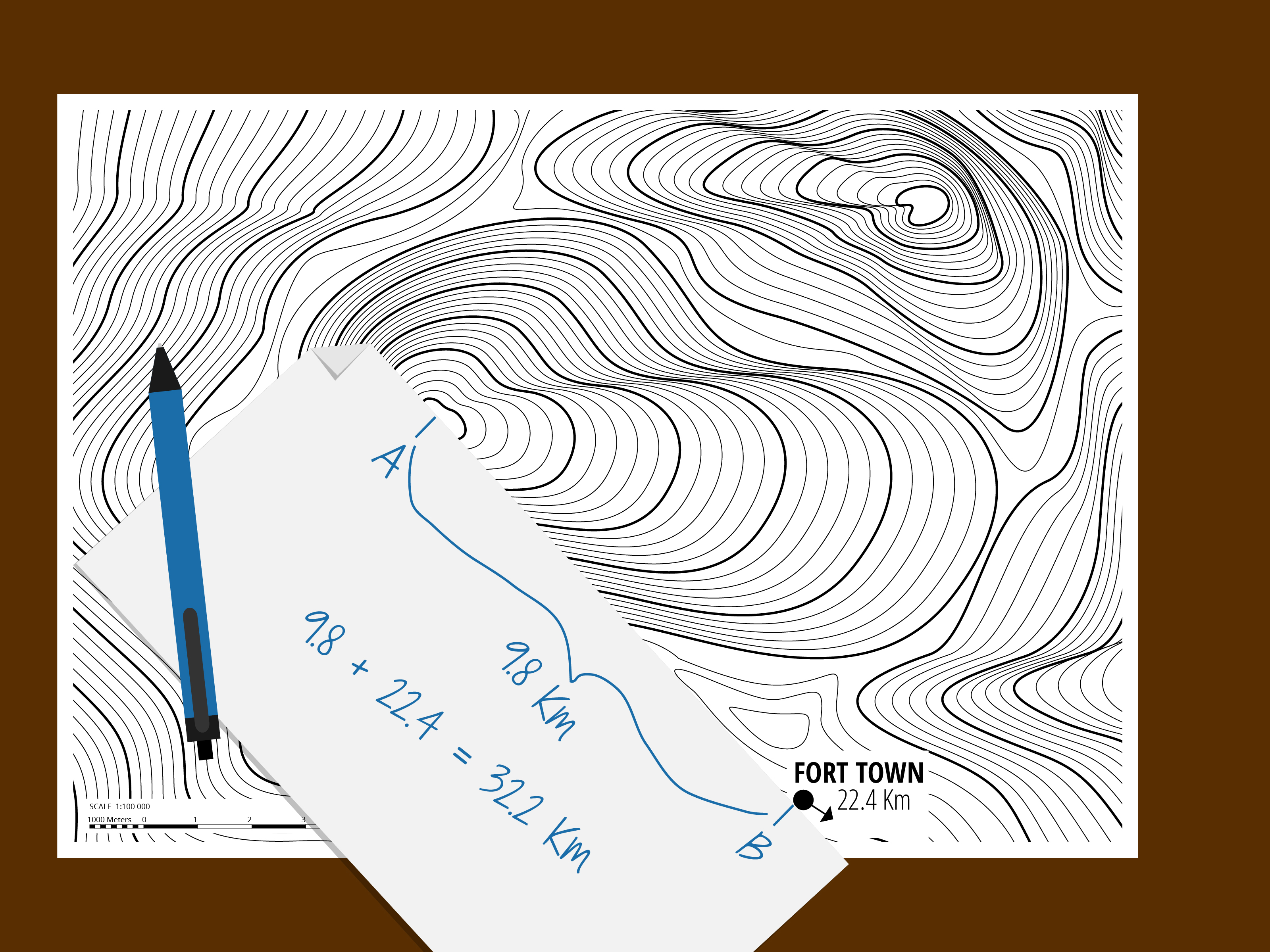
A strip of paper makes an excellent improvised ruler. Place a clean edge against the two locations and mark each endpoint. Then move the paper to the graphic scale and read the distance between the marks.
This technique is useful when working outdoors because a notebook page, index card, or folded map margin is less likely to disappear into the shrubbery than a transparent ruler. Mark the starting point with a small vertical line and label it “A” so you do not accidentally measure from the wrong mark later.
Best Time to Use This Method
Choose the graphic-scale method when speed matters, the map may have been resized, or you want an answer without unit conversions. It is ideal for hikers, students, search teams, field crews, and anyone whose calculator has chosen an inconvenient moment to become decorative.
Method 2: Calculate Distance from the Representative Fraction
The representative-fraction method is more mathematical but highly flexible. It is useful when the graphic scale is hard to read, when you need a result in a particular unit, or when recording calculations for a report.
The Basic Formula
Ground distance = map distance × scale denominator
The units must remain consistent during the multiplication. If you measure the map in centimeters, the initial ground result will be in centimeters. If you measure in inches, the initial result will be in inches.
Example Using a 1:24,000 Map
Assume two water sources are 3.35 inches apart on a correctly printed 1:24,000 map.
3.35 inches × 24,000 = 80,400 inches
Convert inches to feet:
80,400 ÷ 12 = 6,700 feet
Convert feet to miles:
6,700 ÷ 5,280 = 1.27 miles
The straight line distance is approximately 1.27 miles.
Metric Example Using a 1:25,000 Map
Suppose two points are 8.4 centimeters apart.
8.4 centimeters × 25,000 = 210,000 centimeters
Because 100,000 centimeters equal 1 kilometer:
210,000 ÷ 100,000 = 2.1 kilometers
The horizontal distance between the two points is 2.1 kilometers.
Useful Scale Shortcuts
| Map Scale | 1 Inch Represents | 1 Centimeter Represents |
|---|---|---|
| 1:24,000 | 2,000 feet | 240 meters |
| 1:25,000 | Approximately 2,083 feet | 250 meters |
| 1:50,000 | Approximately 0.79 mile | 500 meters |
| 1:63,360 | 1 mile | 633.6 meters |
| 1:100,000 | Approximately 1.58 miles | 1 kilometer |
When the Ratio Method Can Fail
The printed ratio is valid only when the map is displayed or printed at its intended size. A PDF printed with “Fit to Page” may be reduced slightly, making a ruler measurement inaccurate when multiplied by the original denominator.
Check the graphic scale before trusting the representative fraction. Measure a known segment of the bar. On a properly sized 1:24,000 map, a 2,000-foot segment should measure one inch. When it does not, use the graphic scale or determine the actual enlargement factor.
Method 3: Calculate Distance from UTM or Rectangular Grid Coordinates
Some topographic maps include Universal Transverse Mercator grid lines or another rectangular coordinate system. Because these coordinates are usually expressed in meters, you can calculate the straight line distance between two accurately plotted points with the distance formula.
This approach is valuable when coordinates come from a GPS receiver, field notebook, GIS database, emergency report, or survey record. It also avoids measuring a very small map gap with a thick ruler line.
The Distance Formula
For two points with easting and northing coordinates:
Distance = √[(Easting 2 − Easting 1)² + (Northing 2 − Northing 1)²]
This is the Pythagorean theorem wearing hiking boots.
Worked UTM Example
Assume the coordinates are:
- Point A: 542,300 mE, 4,288,600 mN
- Point B: 543,100 mE, 4,289,200 mN
Find the east-west difference:
543,100 − 542,300 = 800 meters
Find the north-south difference:
4,289,200 − 4,288,600 = 600 meters
Apply the formula:
Distance = √(800² + 600²)
Distance = √(640,000 + 360,000)
Distance = √1,000,000 = 1,000 meters
The points are exactly 1 kilometer apart in straight line grid distance.
Important Coordinate Checks
Both points must use the same coordinate system, datum, and UTM zone. Do not subtract a latitude value from a UTM northing or mix coordinates from different datums. The calculation may still produce an impressive-looking number, but so does a vending machine when someone kicks it.
Coordinates read manually from a paper map also have limited precision. If each point is estimated only to the nearest 100 meters, reporting the final answer as 1,003.47 meters would suggest accuracy that the source data do not possess. Round the result to match the quality of the coordinate readings.
How Accurate Is a Topographic Map Distance?
Accuracy depends on the map scale, printing quality, line thickness, endpoint selection, map age, and measurement technique. On a 1:24,000 map, one millimeter represents 24 meters. A pencil mark two millimeters wide may therefore cover nearly 48 meters on the ground.
You can improve the result by marking each endpoint with a fine dot or a short perpendicular tick, using the same edge of the ruler for both marks, and repeating the measurement. For important work, ask another person to measure independently and compare the answers.
Do not add meaningless decimal places. A result of “approximately 1.3 miles” may be more honest than “1.27364 miles” when the endpoints are broad trail junction symbols rather than precisely surveyed monuments.
Straight Line Distance Is Not Walking Distance
A ruler ignores terrain. It can draw a cheerful line directly through a canyon, across a lake, over a cliff, and into a restricted area without experiencing even a moment of concern.
Use straight line distance for proximity, bearings, preliminary planning, radio analysis, grid calculations, and rough comparisons. For travel planning, separately measure the actual trail, road, stream, or proposed route. A curved route can be measured with string, flexible wire, repeated divider steps, or a digital mapping tool.
Elevation also increases the physical distance between two locations. If the horizontal distance is 1,000 meters and the elevation difference is 300 meters, a simplified direct slope distance is:
√(1,000² + 300²) = approximately 1,044 meters
Real ground travel may be longer still because hillsides are irregular and routes rarely follow one perfectly straight slope.
Common Mistakes to Avoid
- Using the wrong scale: Read the scale printed on the specific map sheet.
- Measuring a route instead of a straight line: Draw or imagine one direct line between the endpoints.
- Trusting a resized ratio scale: Verify it against the graphic bar.
- Mixing inches and centimeters: Keep units consistent until the conversion step.
- Measuring from symbol edges: Use the center or defined reference point of each symbol.
- Confusing horizontal and slope distance: A paper map measurement is generally horizontal.
- Ignoring coordinate systems: Grid calculations require matching zones, datums, and units.
- Reporting excessive precision: Round according to the scale and quality of the source data.
Practical Experiences That Make Topo Map Measuring Easier
People usually understand map scale in a classroom and truly learn it after making one or two mistakes outdoors. A useful practice exercise is to choose two unmistakable landmarks near homea road intersection and a bridge, for examplemeasure their straight line distance three different ways, and compare the answers. When the ruler, fraction, and grid methods agree within a reasonable margin, the process begins to feel less like cartographic wizardry and more like ordinary measurement.
One common field lesson involves folded maps. The two desired points have an almost supernatural ability to land on opposite sides of a crease. Instead of flattening the whole map in the wind, place a narrow strip of paper over the points and mark the endpoints. The paper can then be carried to the scale bar without wrestling a map that has suddenly decided it is a sail.
Another practical lesson concerns waterproof maps. Their surfaces resist rain beautifully but may also resist pencil marks with equal enthusiasm. A fine permanent marker works, but it should be used sparingly. Marking the wrong trail junction in permanent ink creates a lasting monument to confidence. A grease pencil or removable map marker is often a friendlier option.
Students frequently obtain different measurements because they have selected different centers for the same symbol. A campground icon, building square, summit triangle, or road intersection occupies measurable space on a large-scale map. Before measuring, define exactly what each endpoint represents. For a summit, use the surveyed point or center of the summit symbol. For a road junction, use the center where the road lines intersect.
Photocopied maps offer another memorable lesson. Someone measures 2.5 inches, multiplies by 24,000, and receives an answer that disagrees with every other clue on the page. The photocopier reduced the map to 94 percent, but the printed “1:24,000” remained unchanged. The graphic scale, having shrunk with the map, reveals the problem immediately. Verifying one scale segment before doing several calculations can prevent an afternoon of confidently wrong arithmetic.
Grid-coordinate work creates a different kind of experience. The mathematics is straightforward, but digit transposition is not. Writing 4,298,600 instead of 4,289,600 moves a point by nine kilometers. Experienced navigators write eastings and northings on separate lines, align the digits, calculate each difference independently, and perform a quick visual check against the map. If the formula says two neighboring hills are farther apart than two cities, the calculator is probably innocent.
Field practice also teaches the importance of scale choice. A 1:100,000 map may be excellent for understanding a large region but poor for measuring the distance between nearby springs. The same endpoints occupy more paper space on a 1:24,000 map, allowing a finer measurement. For local navigation, the map with greater detail usually produces a more useful result.
The final lesson is to compare map distance with terrain. Measure the straight line first, then study contour spacing, water features, vegetation, cliffs, roads, and boundaries. A 0.8-mile direct line across tightly packed contours may require more time and effort than a 1.6-mile trail around the slope. Distance answers “how far,” while the rest of the topo map answers the equally important question: “What is waiting between here and there?”
Conclusion
There are three reliable ways to measure a straight line distance using a topo map. The graphic-scale method is fast and dependable, especially on resized maps. The representative-fraction method provides flexible unit conversions and clear written calculations. The grid-coordinate method delivers a strong mathematical solution when accurate rectangular coordinates are available.
Whichever method you choose, verify the scale, identify precise endpoints, keep units consistent, and remember that a straight line is a horizontal planning measurementnot a promise that the terrain will cooperate. Topographic maps are wonderfully informative, but they have never personally carried a backpack uphill.